Science Report – July 25th
REGOLITH-LANDFORM UNITS AT HAUGHTON CRATER
Jonathan Clarke
WHAT IS REGOLITH?
“Regolith” is a general term used to refer to all weathered earth surface materials extending from the interface with unweathered bedrock at depth to the surface (Eggleton 2001). It includes in situ weathered material derived directly from the underlying bedrock, and transported material derived from both bedrock and other regolith materials, and in many ways is similar in its usage to “surficial material”. Integrated regolith studies are relatively new (Ollier and Pain 1996, Eggleton and Taylor 2001) but regolith materials have been studied in a number of disciplines for some time. These disciplines include pedology, geomorphology and aspects of sedimentology, but rarely traditional geology. Regolith Regolith is very closely associated with landforms, which makes a landscape approach to regolith mapping most appropriate6. Landforms and regolith are formed by essentially the same groups of processes, and once the inter-relationships between regolith and landforms are understood, landforms can be used to predict regolith patterns. Thus landforms are used as a proxy for the largely hidden regolith. This means understanding the dynamics of the present landscape. It also means understanding the dynamics under which relict landforms and regolith materials formed.
REGOLITH-LANDFORM MAPPING
Regolith-landform mapping is an approach to describing the earth’s surface in terms of both landforms and the surface materials, whether of transported material, weathered rocks, duricrust, or fresh bedrock. The techniques of regolith landform mapping have been developed in Australia (Pain et al., 2007, Pain 2008), and have proved an important part of terrestrial field study of surface materials, landscape, biota, and hydrogeology. It is also an essential platform on which to base more specific applications, such as civil engineering, hydrology, resource extraction, landscape ecology, or geophysical and geochemical research. Regolith-landform mapping can be readily applied to the regional to the site scale. The method can also be applied in Mars analogue environments and to the surface of that planet (Clarke and Pain 2004). Regolith-landform mapping has been developed largely in temperate, arid, and tropical environments, one of my aims while at FMARS is to extend the technique to cold climate environments, building on experience gained in Ladakh in the Karakoram in NW India in 2016. Improved mapping in such environments is especially relevant to characterizing sites on Mars.
METHODOLOGY
On arriving at a site a reconnaissance of the area gives a good idea of the general features of the landscape, and allows you to place the different regolith materials in context. It also allows you to check the general relationships between regolith and geology. Observations of the landscape (in its broadest sense) can give a lot of detail that is useful for explanations of the landscape – its origins, active and relict geomorphic and weathering processes, and any information that will allow extrapolation to areas you will not be able to visit. In most cases it is possible to extrapolate your observations from accessible areas into areas that cannot be reached. Wherever possible, use riverbanks or other exposures for your observations of rock types and regolith.
EXAMPLE
An example of regolith-landform mapping in a cold climate is shown in Figures 1 and 1. Both are from the Ladakh region, using public available data. Figure 1 is a map of an area, and Figure 2
Figure 1 shows an interpreted ground level image of a steep, glacier headed valley, Figure 2 is an interpeted Google Earth image of the same area. The units consistent in each Figure.
Each unit consists of regolith defined by a single landform and are homogeneous composition at the scale of mapping. Regolith landform units are characterised by three properties: a landform descriptor in lower case letters forming a prefix, a regolith material descriptor in upper case letters with lower case letters in brackets to describe intersitial ices, salts and carbonates (if present), and a numerical modifier for periglacial modification (if present) as a suffix. Each descriptor is unique.
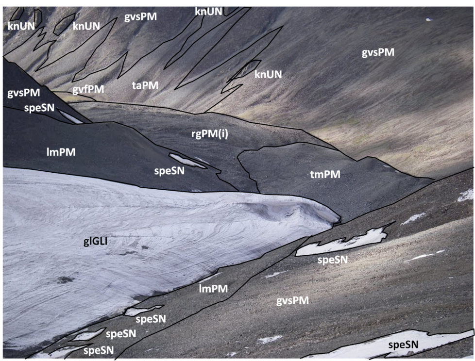
Figure 1. Site-scale regolith-landform units mapped onto a ground level photograph from Phyang glacier terminus, Ladakh (source image http://www.panoramio.com/photo/33652395).
The units in Figures 1 and 2 are as follows:
- gvfPM = glacial valley floor, polymict materials
- gvsPM = glacial valley sid,e polymict materials
- glGLI = glacier, glacial ice
- lmPM = lateral moraine, polymict materials
- knUN = knob, undifferentiated materials
- rgPM(i) = rock glacier, polymict materials, ice cemented
- speSN = snow patch, seasonal snow
- taPM = talus apron, polymict materials
- tcPM = talus cone, polymict materials
- tmPM = terminal moraine, polymict materials
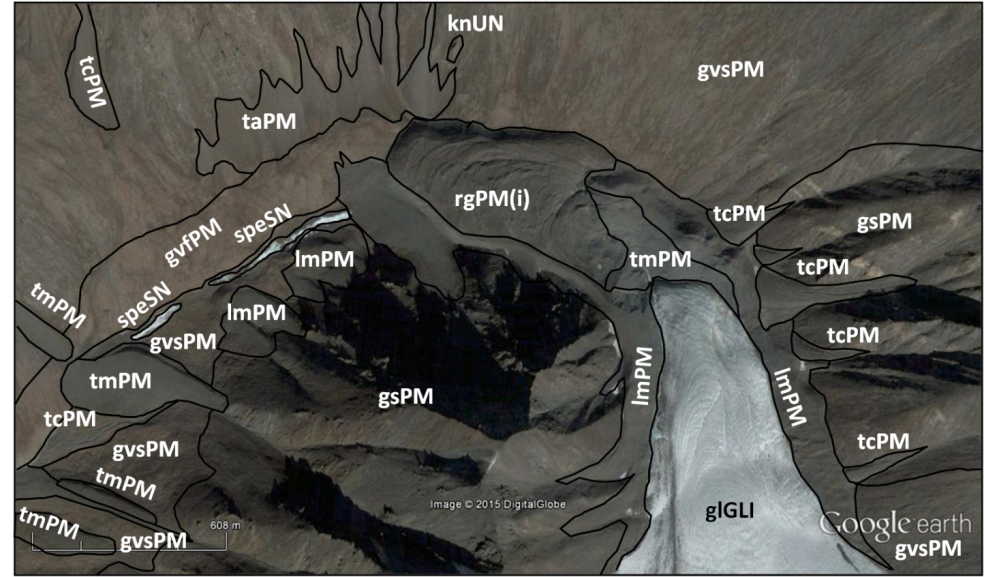
Figure 2. Regolith-landform map of the Phyang glacier in Ladakh. Location 34° 17′ 33.66″ N 77° 33′ 12.69″ E.
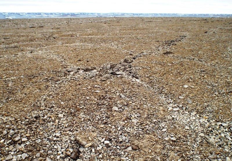
Figure 3. Hierarchical networks of sorted stone polygons on the slopes of Haughton crater. Larhe rocks define larger polygons, smaller polygons are defined by smaller rocks within the larger polygons. Features such as these are the focus of study by Paul Knightly on this expedition
APPLICATION
This methodology will be used to characterize the regolith landform units of specific sites at Haughton Crater from data collected during our expedition and building on earlier work in the area such as that of Lacelle et al. (2008) on the polar desert landscape of Haughton crater and Dyke (2001) on regional mapping of the surficial geology. Examples of some of the local regolith landscape elements are shown in figures 3 and 4.
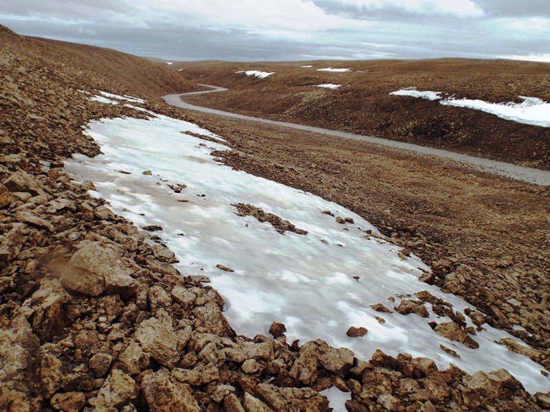
Figure 4. Frost shattered dolostones reworked into block streams for many of the steeper slopes in Haughton crater. Relict snow and ice patches persists well into summer and alluvial deposits mantle valley floors.
REFERENCES
Clarke, J. D. A. and Pain, C. F. 2004. From Utah to Mars: regolith-landform mapping and its application. In Cockell, C. S. (ed.) Mars Expedition Planning. American Astronautical Society Science and Technology Series, 107: 131-160.
Dyke, A. S. 2001. Surficial geology, western Devon Island, Nunavut. Geological Survey of Canada Map 1972A, scale 1:250,000.
Eggleton, R.A. (compiler) 2001. Regolith Terminology. Cooperative Research Centre for Landscape Evolution and Mineral Exploration, Perth/Canberra, 375p.
Eggleton, R. A. and Taylor, G. 2001. Regolith geology and geomorphology. John Wiley & Sons.
Lacelle, D., Juneau, V., Pellarin, A., Lauriol, B., and Clark, I. D. 2008. Weathering regime and geochemical conditions in a polar desert environment, Haughton impact structure region, Devon Island, Canada. Canadian Journal of Earth Sciences 45, 1139-1157.
Ollier, C. D. and Pain, C. F. 1996. Regolith, Soils and Landforms. Chichester: Wiley.
Pain, C.F. 2008. Field Guide for Describing Regolith and Landforms CRC LEME, c/o CSIRO Exploration and Mining, PO Box 1130, Bentley WA 6102, Australia, 94pp.